Soil erosion has turned out to be one of the most challenging issue for the sustainable development of Nepal despite several infrastructural, awareness-raising and policy measures. Erosion and deposition are responsible for transformations into many landforms. Erosion is the transport of sediments. The water velocity carrying eroded soil due erosion is slowed down as soon as flat topography is met or flows into a body of still water. In the meantime, the sediments carried is settled in the form of deposition. Several different approaches ranging from ground surveying, utilizing high resolution satellite imageries used to be the key step on quantifying the mass deposition from flood. UAV being a rapidly evolving technology has made it possible for various geospatial applications (Molina, 2014). This equipment is either remotely controlled (i.e. flown by a pilot) or can fly autonomously based on pre-programmed flight plans or more complex dynamic automation systems. This study reveals efficacy of UAV for estimating the soil deposition due to flood on a particular section of Punyamata River, Nepal.

Fig: Study Area during Flooding (2017)
Data & Software Used
Primarily, the datasets used were the UAV imageries which were captured in different dates. The first set of data was captured in the year 2016 followed by the data acquisition in the same time next year i.e. 2017. Ground control points (GCP) were established using the Differential Global Positioning System (DGPS). The raw data from DGPS were processed using the licensed version of Carlson GNSS software. For flight planning purpose, Pix4D capture mobile app was used Pix4D Mapper was utilized for the image processing. The rest of the volume estimation of the spatial extent was carried out in GIS.
Result and Discussion
The spatial variability of accumulated soil deposition from the annual flooding between the study period is represented below. Deposition seemed to be normal at the upper section of the river whereas at the middle section of river it seemed to be high as it is the flattest region of the study region. A decreasing trend of deposition was observed at the southern end of the river as there was rapid change in elevation of the river. Moreover, in general the deposition was observed to be most in certain buffer zone of river. The total volume of soil deposition was evaluated to be 74161.4239 m3.
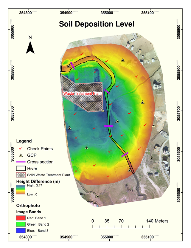
Fig: Soil Deposition Map
River Track Change Analysis
Apart from soil deposition over the area, a noticeable change in river track was also observed which could be a valuable information for those who are studying the river track change analysis and its impact in agriculture as well as river discharge.

Fig: Change in River course
